Fort Langley parking on a festival weekend
The circling, the hopeful signal, the spot that was a driveway. And the real answer: where the lots are, what they cost, and the bus.
Saturday’s Cranberry Festival was, by every account, lovely. More than 125 vendors along Glover Road, a pancake breakfast from 8 am, the village full by mid-morning. We know it was full by mid-morning because we spent that part of it in a slow parade of cars doing laps of the same six blocks, every driver wearing the same expression: hopeful, then betrayed.
You know the dance. Someone is walking toward a car. You slow. You put on your signal as a claim, like planting a flag. They open the trunk, put in a bag, and walk away again. Further on, a glorious open spot that turns out to be a driveway, then a hydrant, then a space exactly 80 centimetres shorter than any vehicle sold since 1994.
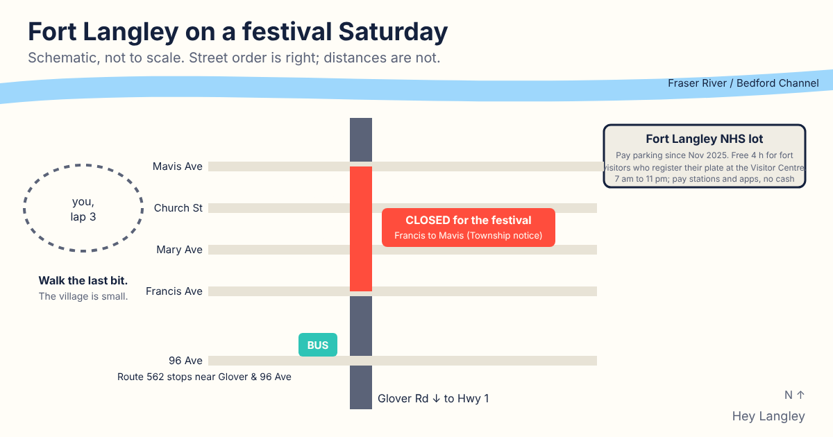
To be clear, this is not a Fort Langley problem in the sense of anyone doing anything wrong. It is a small village built around one main street, and on a festival day that one main street is closed, by design, so that thousands of people can walk down the middle of it eating things. The Township posted the closure of Glover Road between Francis and Mavis Avenues in advance. The circling is what happens when everyone arrives in a car at the same hour and hopes.
Which is the part we can actually fix, because most of the circling comes from not knowing the answer before you leave the house.
What would fix it
A parking plan that is published before the day, in one place, by the people who run the event: here are the lots, here is what they cost, here is the bus, here is when the village typically fills. Half the drivers on their third lap would have happily parked at the first lot if they had known there would not be a second one. We could not find an official festival shuttle or overflow-lot map this year; if one existed and we missed it, tell us and we will link it. Until then, here is the version we can source.
Where to act
- The fort’s lot is a real option, and it costs money now. Parks Canada introduced pay parking at Fort Langley National Historic Site on November 1, 2025. If you are visiting the fort itself, you park free for up to four hours, but you have to register your plate at the Visitor Centre. Otherwise you pay at the machine or by app, credit card only, and the lot is open 7 am to 11 pm. Parks Canada’s own page says the village also has a mix of free and paid street and lot options. Details on its parking page.
- Take the bus. Parks Canada notes that TransLink’s Route 562 stops near Glover Road and 96 Avenue. Put your address and “Fort Langley” into the trip planner and see what it says. On a festival day, a bus that drops you on the edge of the closure beats a car that cannot get near it.
- Arrive early or arrive late. The festival ran 10 am to 4 pm. The breakfast crowd gets the spots. The after-2 pm crowd gets the breakfast crowd’s spots.
- Check the closure first. The Township posts road closures for festivals and events on its closures and impacts page, so you know which blocks not to aim for.
- Walk the last bit. Fort Langley is small. A ten-minute walk from the edge of the village is shorter than a third lap.
For everything else about the village, the fort, the museum and the river, see our Fort Langley guide. Next year’s festival date will go on What’s On as soon as it is announced.