Why Langley's roads bend, jog and cut corners: a road-by-road explainer
Most of Langley's roads sit on a survey grid laid out from an 1859 line in Surrey. The ones that don't, from Fraser Highway to Glover Road to the Five Corners, are older than the grid, follow a railway, or were bent on purpose.
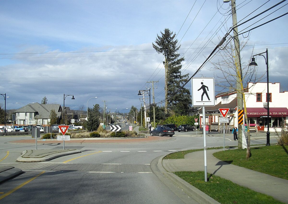
Most of Langley’s main roads run ruler-straight, north-south or east-west. Then Fraser Highway slices across them at an angle, Glover Road wanders off toward the river, and at Murrayville five roads meet in a roundabout. If you’ve ever lost an argument in the car about why, this one’s for you.
The short answer: most of Langley’s roads sit on a survey grid drawn up in the 1800s. The ones that don’t are usually older than the grid, following a railway, or bent on purpose much later to get around farmland or trains. Here’s the long answer, road by road.
First, how the grid works
In 1859, a contractor named J.W. Trutch, hired by the colony and working with the Royal Engineers, started cutting a line north from where the border meets Semiahmoo Bay. That line is the Coast Meridian, today’s 168 Street in Surrey. Surrey’s historians say it and an east-west survey line, Townline Road (today’s 96 Avenue), became the basis for every land survey in the lower Fraser Valley.
From those lines, the land was carved into townships six miles square, each holding 36 sections of one square mile. The lines between sections are where the roads ended up, which is why so much of Langley feels like a sheet of graph paper.
The street numbers simply count that grid. Avenues start at 0 on the border and go up eight per mile, so 80 Avenue is ten miles north of the U.S. Streets climb eight per mile going east, and every eighth one (200, 208, 216, 224…) tends to be a main road with a looser maze of streets inside each block.
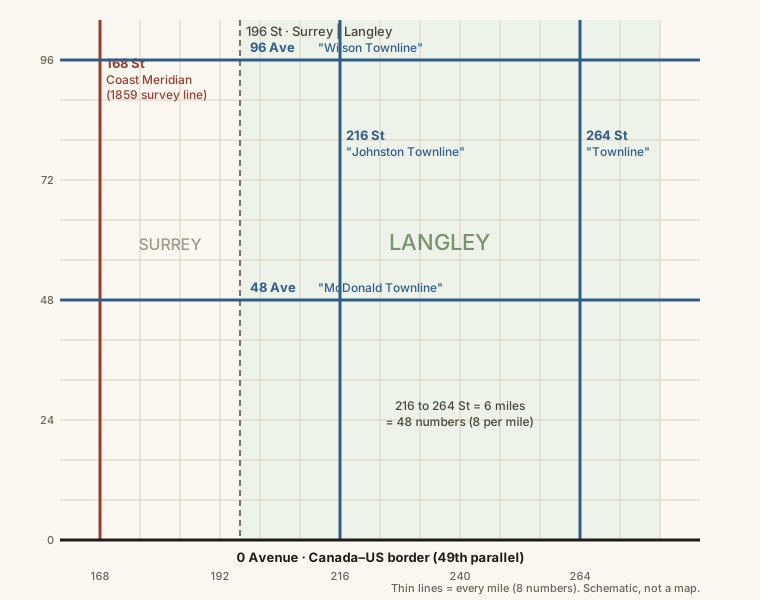
Here’s the part we love, and to be clear, it’s our own observation rather than something we found in a history book. Look at the old names the heritage society has collected for Langley’s roads, and the word “Townline” keeps turning up: 216 Street was Johnston Townline, 264 Street was Townline, 48 Avenue was McDonald Townline and 96 Avenue was Wilson Townline. Now do the arithmetic. At eight numbers to the mile, 216 is 48 numbers, or six miles, east of the Coast Meridian at 168, and 264 is another 48 numbers, six miles, beyond that. 48 Avenue is six miles north of the border and 96 Avenue is twelve. Six miles is exactly the width of a survey township, so our guess is that settlers were naming the township lines. We haven’t found a survey record that confirms it, and the pattern isn’t perfectly tidy: the Township’s heritage study also mentions a “Town Line Road” up in Walnut Grove.
The grid reached different corners at different times. The Alder Grove Heritage Society points to a government report saying the Aldergrove area (Township 13) was surveyed and opened to settlers in 1876, and one surviving 1890 Crown grant puts a 160-acre farm in the southeast quarter of Section 30, Township 13. That farm belonged to Philip Jackman, a former Royal Engineer who later became reeve.
- The rule of thumb
- Straight and numbered: a survey line. Angled or curving with a name: probably older than the grid, or built around something.
- 1 mile
- 8 street or avenue numbers
- Survey lines
- 168 Street (Coast Meridian, cut from 1859) and 96 Avenue (Townline Road)
- Surrey / Langley line
- 196 Street
And why do straight roads still jog?
A grid on a surveyor’s plan isn’t a road. According to the Township’s heritage study, the hard work of actually building early roads meant they often had to curve instead of sticking to a straight allowance. Roads went in piece by piece: an 1876 road tax, then an 1896 bylaw requiring adult men to put in days of roadwork in proportion to the value of their land, and farmers building their own links out to the main roads. Some land was laid out before the grid, too, most visibly the old Hudson’s Bay Company farm at Milner (more on that below).
We went looking for a documented reason behind particular jogs in our numbered roads, and couldn’t find one we’d stand behind. If you know of a Township record or survey plan that explains one, send it our way and we’ll add it.
When the numbers replaced the names
This is where the record argues with itself. The Langley Heritage Society says the Township moved to numbered streets and avenues in 1946, and the City’s own 70th-anniversary history says the names disappeared “in the 1940s.” The Township’s 2017 heritage study says Langley Township adopted the grid system in 1957 along with other BC municipalities, that a 1958 Fraser Valley map printed both old names and new numbers, and that the City and Township changed over gradually from 1960. Surrey’s historians also date Surrey’s switch to 1957.
One way to square it: the Township study’s own timeline has the change rolling out gradually from 1960, so a plan from earlier and new signs in the 1960s could both be true. We couldn’t find the council decision itself to settle it. Either way, the old names were a mess. The heritage society says 200 Street alone went by five different names along various stretches, including Griffith, Hunter and Carvolth. Many old names live on through the Heritage and Pioneer markers Township Council has put up along the roads, so keep an eye out for a second, older name on a small sign.
Why 0 Avenue is the border
The 1846 Oregon Treaty made the 49th parallel the line between British and American territory. British and American boundary teams marked it on the ground between 1857 and 1861, cutting a cleared strip about 40 feet wide through the forest and setting iron posts and stone cairns along it.
A trail ran along that cleared line from 1858, cut by the Royal Engineers and American surveyors, and that is the ancestor of 0 Avenue. When the numbering came, the border was the obvious zero.
0 Avenue crosses the entire Township from Surrey to Abbotsford, and the heritage study names it the longest of Langley’s declared “country roads.” Some sections weren’t paved until the 1970s and 80s. Near the Aldergrove crossing, Boundary Road on the Washington side runs right alongside 0 Avenue for about a mile and a half, with only a strip of grass between two countries. Our border crossings guide has the practical side.
Why Fraser Highway runs on the diagonal
Because it was there first. Fraser Highway is the Yale Road, the colonial route from New Westminster to Yale at the head of steamboat navigation on the Fraser. Surrey’s heritage register dates the trail to 1861 and its upgrade to a wagon road to 1865. The Township’s study says it was “little more than a quagmire” until 1875, when a contract was let to W.H. Vanetta to improve it. (The same study also dates construction of the wagon road to 1872, so treat the exact year as contested.)
Nobody surveyed a grid first and then built the Yale Road on it. Its builders worked with the ground in front of them, and the Township’s study says diagonal routes like this “follow the topography.” Surrey kept one section near 186 Street on its heritage register precisely because it shows the twisting alignment the original builders used.
It wasn’t a comfortable road. One traveller in 1891 found a stretch east of Innes Corners “so abominable” that he couldn’t do justice to its condition, according to the City’s history. In the 1920s and 30s the route was upgraded for cars, and in 1930 it became part of the Trans-Canada route. (Exactly when the Fraser Highway name took over depends on who you ask: Surrey ties it to the 1930s upgrade, the City’s history to the arrival of Highway 1.) It stayed the valley’s main east-west road until the freeway, Highway 1, was finished in the early 1960s; the Township study gives 1964. Now it’s getting its next layer: the SkyTrain extension follows Fraser Highway into Langley City.
Old Yale Road and the Five Corners
As the highway was realigned for cars, the older route through Murrayville kept the name Old Yale Road. That’s why there are two Yale roads, with the old one running a little south of Fraser Highway past the airport.
Murrayville started as Murray’s Corners. Canada’s Historic Places records that Paul Murray’s family took Crown grants of 160 acres on each corner where the Yale Road met the Fort Langley Trail, the route north to the fort. Billy Murray built a hotel there between 1885 and 1889; the Traveller’s Hotel at 21628 48 Avenue is listed on the Canadian Register of Historic Places as the oldest remaining structure in Murrayville. The name changed to Murrayville around 1911, reportedly at the post office’s request.
Today that meeting point is the Five Corners, where 216 Street, 48 Avenue and Old Yale Road come together, now handled by a roundabout.
Old Yale Road has one more story under the tires. In 1922, the three-kilometre stretch between Langley Prairie and Murrayville was paved in concrete by the A.B. Palmer Co., and in 1923 the premier of the day officially opened it from the porch of the Murrayville store. The Township says those panels were very likely the first concrete road surface in BC. For a century they stayed in the road past Langley Regional Airport, cracked into a pattern the heritage society photographed in 2023 and captioned “the veins of time.” That year the Township asked residents what to do with the worn-out road, and the society backed rebuilding a short stretch west of the Five Corners as a commemoration and bringing the rest up to asphalt standard. Council then approved a $9.9 million rebuild of Old Yale Road from 216 Street west to the City boundary, with new pipes, a multi-use path, traffic calming and heritage interpretation areas. The Township’s project page said in May 2026 that the road work was complete, with finishing touches still going into the commemorative plazas at the roadside. We couldn’t confirm how much of the original concrete is still visible, so if you go looking, start at the plazas.
Glover Road: a trail, then a trunk road
Glover Road runs at its own angle because the route is older still. The City’s history calls it Langley’s first road and traces it to 1824, when the Hudson’s Bay Company’s James McMillan followed an ancient Indigenous trail northeast from the Nicomekl River, a route so “soft and miry” it took a full day to reach the Salmon River. The company later used that trail to link the fort with its farm on Langley Prairie, and in 1874 it was graded, widened and extended to meet the wagon road. The City’s account doesn’t name the trail outright, but the road that came to join fort and prairie was the Langley Trunk Road. After the First World War the Trunk Road was renamed for Lieutenant Frank W. Glover, Langley’s municipal engineer, who served with the Canadian Engineers and died shortly after the war ended. Several Langley Prairie roads were renamed for soldiers around then; the City’s history says Glover is the only one of those names still in use.
Milner’s tilted streets
Where the BC Electric interurban crossed the Trunk Road and the road to Murrayville (today’s 216 Street, the old Johnston Townline), the village of Milner grew up. It grew on land the Hudson’s Bay Company had farmed since 1833 before selling it off in lots, and the Township’s heritage study says you can still read the farm in the map: its streets are laid out on a slant, out of step with the surrounding grid.
Langley City: two old roads and a railway
The City’s 70th-anniversary history opens by admitting its streets “cross the prevailing grid at seemingly irrational angles.” The reason is right on the City’s coat of arms, which shows the crossroads of Old Yale Road, Glover Road and the BC Electric Railway, with a star for Innes Corners, the settlement’s first name.
The interurban opened in 1910, and the Township’s study places Langley Prairie exactly where its line met the Yale Road and the Trunk Road. One City street, Grade Crescent, was built on the bed of a railway line that no longer exists. Before numbers, 200 Street was Griffith Road and then Hunter Road, part of 201 Street was Mableson Road, 207 Street was Blacklock Lane and part of 208 Street was Rinn Road.
Trails that never went away
Telegraph Trail. In April and May 1865 the Collins Overland Telegraph line was strung through north Langley, part of a scheme to wire North America to Russia that died when the Atlantic cable won the race. The Township’s study says pieces of its path are still roads today: the twisting rural lane called Telegraph Trail, which runs in the 72 to 80 Avenue band of northeast Langley, and a section between 216 Street and Glover Road.
Allard Crescent. Out along the river toward Derby Reach, Allard Crescent traces the first wagon trail east to the fort, according to the Township study. The heritage society says it’s named for Eugene Allard, a First World War soldier killed at Ypres.
The bends we built on purpose
Not every curve is old. Some were drawn in the last 60 years to get traffic around something.
The Langley Bypass. The bypass around downtown Langley opened in 1966, at first running only as far east as Glover Road; the section from Glover on to Fraser Highway followed in 1980. (Those dates come from Langley Advance reports cited in Wikipedia’s account of Highway 10; we couldn’t open the papers ourselves.) It’s why Highway 10 swings around the north side of the City instead of going through it.
Mufford Crescent. The road was named for the Mufford farming family when it was put through from 64 Avenue to Glover Road. Its overpass was officially opened on September 4, 2014, the last of nine Roberts Bank Rail Corridor projects, at a cost of about $51 million, to get road traffic off an at-grade crossing with the busy port rail line. The first design was turned down by the Agricultural Land Commission; the reworked one, with a connection to Glover Road, took far less farmland. The road layout you drive today is that second version.
University Drive. The newest bend on the list. Built as the 80 Avenue extension and opened on August 24, 2018, it runs from 216 Street at Labonte Avenue down to a roundabout at Glover Road and Trinity Western University. Its engineers had to deal with grades over six per cent, creeks at the bottom of the slope and a big stretch of Agricultural Land Reserve, and the project manager said the ALR approvals alone took about a year. What you drive today curves down the hill to Glover rather than running ruler-straight like the rest of 80 Avenue.
Go see it for yourself
Four stops that show the whole story in an afternoon: the Five Corners, the rebuilt heritage stretch of Old Yale Road, Milner’s crossroads, and the end of the grid at 0 Avenue.
For the bigger picture, our history of Langley covers the railways and floods, and the Langley Heritage Society and Langley Centennial Museum hold the old maps and Maureen Pepin’s 1998 book Roads & Other Place Names in Langley, B.C., the source for most of the old road names. If you’re out looking, the Murrayville guide has where to stop for a coffee.