Bedford Channel at its calmest and lowest: where to stand, and why the water is so far down
Fort Langley's side of the Fraser is at its stillest and lowest right now. Four public spots to watch it at first light, the gate hours that matter, and the snowmelt reason the channel drops every autumn.
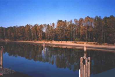
A Fort Langley photographer sent the Langley Advance Times a set of pictures last week: the Bedford Channel at dawn, “as calm as glass,” taken from Brae Island looking back at the canoe club, plus a few of what the paper called an exceptionally low tide, with the channel pulled back to a strip of mud and old pilings. If you have wondered where to stand for that view yourself, here is the short answer, and the reason the water is so low in the first place.
What you’re looking at
The Bedford Channel is the Fraser’s side channel between Fort Langley and McMillan Island, which Parks Canada describes as the home of the Kwantlen community. The park at the island’s western end that everyone calls Brae Island is officially the west part of McMillan Island. So the far bank, outside the regional park, is somebody’s home: enjoy it from this side or from the park trail, not from the mudflats.
Why it drops every autumn
The Fraser is a snowmelt river. Its big flows come in late spring and early summer, when the interior snowpack goes (the freshet that fills the flood forecasts every May and June), and it falls away through the summer. By October it is close to its yearly low, until the Pacific storm season from October to December gives it a smaller second bump. On top of that the lower river here is tidal, which is why Metro Vancouver’s Brae Island page files the fishing under federal tidal rules. Put a low river together with a low tide and you get the mud-and-pilings version of the channel. The nearest gauge is Environment Canada’s Fraser River at Mission station, if you want to check the level before you go.
Four places to stand
Marina Park, foot of Church Street. The Township lists it as dawn to dusk, with a boat launch, trails, parking and a washroom. You are on the south bank looking straight across at the island, and it is the easiest spot to reach for first light: park, walk a few steps, done. If you want to launch a canoe or paddleboard, the club dock on Billy Brown Road and Marina Park’s launch are both on this stretch; see our Fort Canoe and Kayak Club page for where club members park.
The channel trail at Bedford Landing. A flat gravel path runs along the water behind the newer houses west of Glover Road, with the Fort Langley Boardwalk behind the Fort Pub at the Glover Road end. Our Bedford Landing page has the map. Note that the Fort-to-Fort Trail beyond it has been affected by dike work on the Salmon River this fall; check the Fort-to-Fort Trail page before planning a long walk.
Tavistock Point, Brae Island. Over the Jacob Haldi Bridge, turn into the regional park lot and walk the Tavistock Point Trail: 2.1 km of firm gravel with several viewpoints, some with one step up to a platform. The ones on the channel side look back at the village and the canoe club, which is where last week’s dawn photo was taken. Two things to know. The park gate opens at 7 am and from November 3 closes at 6 pm, locked. And dogs stay on leash, drones stay home.
The fort’s river viewpoint. Parks Canada says its Visitor Centre has a view over the Fraser; it opens 11 am to 4 pm daily, so this is the lunchtime option rather than the dawn one. Park in the EasyPark lot at the end of Mavis Avenue and register the car at the Visitor Centre; the first four hours are free for fort visitors. Our Fort Langley National Historic Site page has the admission details.
When to go
By our clocks, sunrise is around 8 am in early November and gets later through the month, so a “dawn” photo no longer means a 6 am alarm. The glass-calm look needs still air, which around here usually means a cold, clear morning before any wind gets up. For the low-water look, go after a dry week and check the river level first. For more river views and the winter closing times for the regional parks, see our Fort Langley village guide and Brae Island Regional Park.